To recap, three settings (parameters) together completely describe the alignment of a fixed dish:
All these values are completely determined by:
Because it depends on whether longitudes are west (-ve) or east (+ve), and latitudes south (-ve) or north (+ve), azimuth is rather unwieldy for the purposes of this discussion. Consequently, a more convenient intermediate result in its calculation is used here, the apparent difference in longitude (DLongA), defined as the angle east or west of the dish site's meridian at which the target satellite appears. The actual relationship between the two is:
| Azimuth = | DLong -ve | DLong Zero | DLong +ve |
|---|---|---|---|
| Lat -ve | DLongA | 0 | 360 - DLongA |
| Lat Zero | 90 | 0 | 270 |
| Lat +ve | 180 - DLongA | 180 | 180 + DLongA |
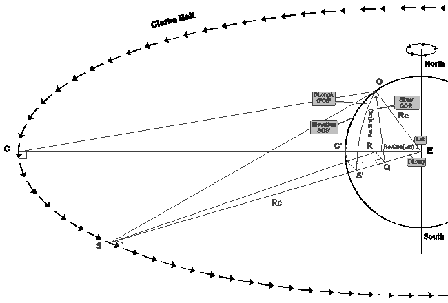
All these angles are marked on the following diagram:

The settings can be derived as follows ...
Consider the spherical triangle OC'S':
| Sin(DLongA) Sin(DLong) |
= | Sin(OS'C') Sin(Lat) |
Spherical Sine Law (18) | |
| ∴ | Sin(DLongA) | = | Sin(DLong).Sin(OS'C') / Sin(Lat) | |
| & | Cos(DLongA) | = | -Cos(OC'S').Cos(OS'C')+Sin(OC'S').Sin(OS'C').Cos(DLong) | Spherical Cosine Law (19) |
| ∴ | Cos(DLongA) | = | Sin(OS'C').Cos(DLong) | OC'S' = 90° |
| ∴ | Sin(DLongA) Cos(DLongA) |
= | [Sin(DLong).Sin(OS'C')] [(Sin(Lat).Sin(OS'C').Cos(DLong)] |
Divide first result by the second |
| ∴ | Tan(DLongA) | = | Tan(DLong)/Sin(Lat) | Tan(A) = Sin(A)/Cos(A) |
| ∴ | DLongA | = | ArcTan[ Tan(DLong) / Sin(Lat) ] |
Consider again the spherical triangle OC'S':
| Cos(OES') | = | Cos(DLong).Cos(Lat) + Sin(DLong).Sin(Lat).Cos(OC'S') | Spherical Cosine Law (11) | |
| ∴ | Cos(OES') | = | Cos(DLong).Cos(Lat) | OC'S' = 90° |
Consider the triangle EOS:
| SO² | = | Rc² + Re² - 2.Rc.Re.Cos(OES) | Cosine Law | |
| ∴ | SO | = | √[Rc² + Re² - 2.Rc.Re.Cos(OES)] | |
| & | Sin(EOS) / Rc | = | Sin(OES) / SO | Sine Law |
| ∴ | Sin(EOS) | = | Rc.Sin(OES) / SO | |
| ∴ | Sin(EOS) | = | Rc.√[1 - Cos²(OES)] / SO | Cos²(A) + Sin²(A) = 1 (5) |
| ∴ | Sin(EOS) | = | Rc.√[1 - Cos²(OES)] / √[Rc² + Re² - 2.Rc.Re.Cos(OES)] | Substitute SO |
| ∴ | Sin(EOS) | = | Rc.√{ [1 - Cos²(OES)] / [Rc² + Re² - 2.Rc.Re.Cos(OES)] } | |
| ∴ | Sin(EOS) | = | √{ [1 - Cos²(OES)] / [1 + (Re/Rc)² - 2.(Re/Rc).Cos(OES)] } | Divide through by Rc |
| ∴ | Sin(EOS) | = |
√
[1-Cos²(DLong).Cos²(Lat)]
[1+(Re/Rc)²-2.(Re/Rc).Cos(DLong).Cos(Lat)] |
Substitute Cos(OES) = Cos(OES') |
| & | EOS | = | 90 + Elevation | By definition |
| ∴ | Sin(EOS) | = | Sin(90 + Elevation) | |
| ∴ | Sin(EOS) | = | Sin(90).Cos(Elevation) + Cos(90).Sin(Elevation) | Compound Angles (1) |
| ∴ | Sin(EOS) | = | Cos(Elevation) | |
| ∴ | Cos(Elevation) | = |
√
[1-Cos²(DLong).Cos²(Lat)]
[1+(Re/Rc)²-2.(Re/Rc).Cos(DLong).Cos(Lat)] |
|
| ∴ | Elevation | = |
ArcCos
(
√
[1-Cos²(DLong).Cos²(Lat)]
[1+(Re/Rc)²-2.(Re/Rc).Cos(DLong).Cos(Lat)] )
|
Consider the triangle EQR:
| QR | = | ER.Sin(DLong) | ||
| ∴ | QR | = | Re.Cos(Lat).Sin(DLong) | Substitute ER |
| & | Tan(Skew) | = | QR / OR | Definition of Tan |
| ∴ | Tan(Skew) | = | Re.Cos(Lat).Sin(DLong) / Re.Sin(Lat) | Substitute QR & OR |
| ∴ | Tan(Skew) | = | Sin(DLong) / Tan(Lat) | Tan(A) = Sin(A)/Cos(A) |
| ∴ | Skew | = | ArcTan[ Sin(DLong) / Tan(Lat) ] |
The following tables show examples of DLongA, Elevation, and Skew:
|
Notes | ||||||||||||||||||||||||||||||||||||||||||||||||||||||||||||||||||||||||||||||||||||||||||||||||||||||||||||||||||||||||||||||||||||||||||||||
|
|||||||||||||||||||||||||||||||||||||||||||||||||||||||||||||||||||||||||||||||||||||||||||||||||||||||||||||||||||||||||||||||||||||||||||||||
|
|
||||||||||||||||||||||||||||||||||||||||||||||||||||||||||||||||||||||||||||||||||||||||||||||||||||||||||||||||||||||||||||||||||||||||||||||
|
|
||||||||||||||||||||||||||||||||||||||||||||||||||||||||||||||||||||||||||||||||||||||||||||||||||||||||||||||||||||||||||||||||||||||||||||||
Note: Sometimes where it is useful to illustrate a point, tables in this and the following page may include data for when a satellite would actually be invisible below the horizon.